|
Reading
Weather, Bar & Ocean Conditions for a Small
Boater
Ocean
fishing in the Pacific Ocean off Washington & Oregon can be a rewarding
experience. It can also be rather exciting under the wrong
conditions. Listed below will be information for you to help understand
what you may be getting into. This is not to scare you off, but to expose
you to some of the things to look for that may help bring you back to port
safely.
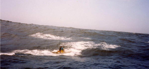
The
picture below is not a bar crossing, but is spectacular enough ocean conditions
to warrant sharing with fishing persons who may have been in situations like
this in a small boat & made it safely back to shore. Some have
been known to even kiss the ground afterwards. The skipper in cases
like this has to be GOOD & having an angel sitting on his shoulder sure
doesn't hurt either.
|
An 18' Boston Whaler
heading for Swiftsure Bank out of Neah Bay in 1991, but they soon turned
back |
|
|
|
The photographer
here being Tim Dahl, running from a companion boat |
Weather: At
the start of the normal bottom-fish seasons in May, there are days when
even the charter boats cancel out due to weather conditions. When the normal salmon
seasons begin, (middle of June or the first of July) the weather may
still be somewhat unpredictable.
If the Dept of Fish & Wildlife give us a early Chinook season, you can expect to
stay on the beach a few days because of bad weather, even up to the end of
July. As the season
progresses, the weather tends to stabilize up to the end of October or so, but the ocean salmon
seasons are usually ended by then.
If there has been a storm, the ocean may take from 2 to 4
days to lay down afterwards. So even if the flags are not flying right
after a storm, you can still encounter rough seas no matter what the tides are.
It
is advisable to listen to VHF Weather channel 3 or 4 depending on your location,
for an updated marine weather
report.
In
the areas that the Coast Guard is stationed, they usually have a tower
that flies the NOOA marine weather warning flags. It is advisable to look at this tower to see if small-craft
warnings are flying before launching if the weather is, or has been
questionable.
NOOA
Weather Warnings:
The NOAA weather warnings and
the USCG Rough Bar warning system are two different things altogether.
Although NOAA will on occasion forecast for rough bar conditions this is strictly due to a offshore weather pattern that has developed abnormal
swells. You can have small craft advisories and not have a rough bar restriction in place as you could
also have a rough bar restriction and not have small craft warnings in effect.
Therefore the NOAA warning flags are not a reliable means of predicting if the bar is restricted.
The primary cause of rough bar conditions is a combination of swell and tidal conditions.
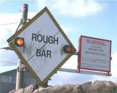
Rough
Bar Closure:
The Rough Bar signs have been in place at
the marina areas since 1980 when the regulation was established. The US Coast Guard is authorized to impose
fines up to $1100 to pleasure boaters & uninspected commercial passenger
vessels for failure to obey imposed bar restrictions, pursuant to
33CFR177.05. At the entrance to most river bars from the harbors
where there are USCG stations, there is a large diamond shaped sign as shown
below. When the amber lights are flashing alternately as shown, will be visible when exiting a boat basin or before you get to the closed
area from upstream if the bar is closed. In the past they would place a Lifeboat on the bar to turn
boaters back, but now that the home Land Security missions have exploded, they are having to find more innovative ways to get the message out to the
public.
These
flashing lights would not be visible from the
ocean outside the bar, but a Coast Guard boat would usually be stationed just
outside the bar patrolling back & forth. If the bar is closed, this
Coast Guard vessel will be displaying a blue flashing light.
To
determine whether the bar will be closed, usually a 47' CG vessel goes out at
the appropriate time & is
stationed inside the bar watching the water conditions. It is their
call & they do have some latitude in making this decision as the minimal
criteria set forth by the Coast Guard would probably close bars the majority of
the time.
Unsafe
bar conditions are defined as:
· Wave height four feet or greater, or,
. Wave height is greater than the length of the boat divided by 10 plus the
freeboard, or,
· The surface current is four knots or greater.
These conditions are the minimum criteria of what is considered unsafe.
But regardless of the means and technology
they can not update the restrictions in the dark, so updated conditions will not
be posted until first light in the morning. This does not help those who are traveling to the area from inland but it is the best
they can do with the technology available. The best way to help boaters is to teach them
how to look a the weather forecast and make informed decisions.
The
USCG are directed by legal stature & do have to direct their closures
to the inexperienced boater. This will no doubt restrict the
experienced boater however. But the experienced inland lake operator's idea of
whitewater is not the same here & he may well be
overconfident, creating potential problems.
The
Coast Guard places different degrees of restrictions, as for 16', 24' or
30' boats.
If you are bigger than the restriction, you may legally cross.
If
the bar is closed, some Coast Guard stations may place personnel at the
launches & on some of the docks to inform boaters. There is in the
process at many bars to have an Low power AM Radio Transmitters that broadcasts repeating weather
forecasts & bar warnings to provide readably accessible
information to the boater as they enter the local area . Also at Westport there in the works for the
2005 season, to install a large white board at the launch area with the
weather/bar conditions.
When the bar is restricted, there is a safety broadcast on channel
VHF channel 16, likewise when the restriction is lifted. There is a recorded phone
message that the public can call to get the restrictions; it also is updated when the conditions change.
The stations also notifies the local radio stations who in turn broadcast the conditions and
restrictions. It is also there to relieve the communications watch stander at the local Coast Guard
Station from having to answer numerous calls on the radio for condition updates.
This will also be handy to inform the boater of a restriction prior to launching or paying ramp fees, just to be turned around on the
bar.
When the lights
are flashing & there is no Coast Guard boat in sight, hail them on VHF radio
Channel 16 and ask for a bar report, and if there are any restrictions.
They will probably have you switch over to Channel 22 to give you the report.
Knowing how to use a VHF radio is also very important.
VHF radios come equipped with three different transmission modes: US, International and Canadian.
In International mode Channel 22 is a duplex frequency which means you will not hear the Coast Guard calling you back.
Make sure that you read your owners manual and know how to set your VHF radio to US frequencies.
If
the bar is closed at Westport, the upstream side will usually be from the
Westport marina entrance buoy #2, north to buoy #13. The ocean side
closure will usually be inside of buoys #4 to #5.
| This sign is just outside the Westport
boat basin on the river side of "The Point" |
 |
Rule
of 12:
|
The formula below is used to calculate the amount of
river flow at a
bar. It is called the "rule of 12". This flow will be best
described as: |
|
1st hour after a tide change will have 1/12th
of the flow |
2nd hour will be 2/12ths |
3rd hour
will be 3/12ths |
|
4th hour will be 3/12ths |
5th hour will be 2/12ths |
6th hour
will be 1/12th |
From
this table you can see that the maximum flow will be the middle 2 hours of an
exchange. This usually equates to the bar being roughest at that time.
How
to Somewhat Understand Offshore Weather
Forecasts:
It is advisable to go to at least one of the
internet marine weather sites, http://www.wrh.noaa.gov/Portland/marine.html
, and also the buoy site http://www.ndbc.noaa.gov/Maps/Northwest.shtml
to get information that at least will give you some idea as to what to expect.
On the buoy site, look at it often enough so you can tell the wave height and
time between the waves as a comparison. It is recommended that you look at
this site before you go there and then when you are there make some notes as to
the sea conditions so you have something to actually compare or visualize what
they are saying.
Many knowledgeable boaters use this general rule, if looking at, or listening to a marine weather
forecast, if the sum of the Wind Waves + the Height of the Swell exceed the Time, in seconds, STAY HOME
Example:
Wind Wave, 2-3 ft + Swell, 7 ft. = 10
Time, in seconds = 7
STAY ON THE BEACH
(Wave + Swell exceeds Time)
The above would in all probability not be realistic
anyway, in that the time would usually be shorter, & therefore rougher
conditions.
Usually the wave heights are not the only thing to look at, as the time between the swells can be a contributing factor. When it gets down to
WW 1', S 5' & Time at 6 seconds, no matter a
lesser height, there is also a closer time, it will be about the same criteria
to stay home, as it WILL be choppy for a small boat. An more ideal day on the water would be a 1 ft WW, 4 ft Swell, & 10
seconds Time. But if you look only for this condition, you had better take
up golfing to fill in. Now if you are watching the buoy reports, the actual height measured on these buoys is usually less than the Wind Wave + Swell
(height in the forecasts).
Here is an actual marine
forecast that should shake the boots off any knowledgeable boater. 30
knot winds & combined seas of 30' at 12 seconds.
COASTAL WATERS FROM CAPE SHOALWATER, WA. TO CASCADE HEAD, OR. OUT
20 TO 60 NM-
9:09 PM PDT SAT MAY 21 2005
...SMALL CRAFT ADVISORY IN EFFECT THROUGH SUNDAY AFTERNOON...
--TONIGHT...SW WIND 20 TO 25 KT. WIND WAVES 6 FT. W SWELL 10 FT AT 10 SECONDS...BUILDING TO 16 FT AT 10 SECONDS. A CHANCE OF SHOWERS.
--SUN...S WIND 25 TO 30 KT...BECOMING SW 20 TO 25 KT IN THE AFTERNOON. WIND WAVES 7 FT. W SWELL 23 FT AT 12
SECONDS...SUBSIDING TO 20 FT AT 12 SECONDS IN THE AFTERNOON. CHANCE OF SHOWERS.
--SUN NIGHT...W WIND 15 TO 20 KT...BECOMING SW 10 TO 15 KT AFTER MIDNIGHT. WIND WAVES 4 FT...SUBSIDING TO 2 FT AFTER MIDNIGHT. W
SWELL 17 FT AT 13 SECONDS... SUBSIDING TO 14 FT AT 13 SECONDS AFTER MIDNIGHT.
--MON...W WIND 5 TO 10 KT...BECOMING NW 10 TO 15 KT IN THE AFTERNOON. WIND WAVES 2 FT. W SWELL 12 FT...SUBSIDING TO 10 FT
IN THE AFTERNOON.
--MON NIGHT...N WIND 10 TO 15 KT. WIND WAVES 2 FT. W SWELL 8 FT.
--TUE...N WIND 10 KT...RISING TO 15 TO 20 KT IN THE AFTERNOON. WIND WAVES 1 FOOT...BUILDING TO 4 FT IN THE AFTERNOON. W SWELL
6 FT.
--TUE NIGHT...N WIND 15 TO 20 KT...EASING TO 10 TO 15 KT AFTER MIDNIGHT. WIND WAVES 4 FT...SUBSIDING TO 2 FT AFTER MIDNIGHT. W
SWELL 5 FT.
Most NOOA marine forecasts are for a 24 hour period, this means the forecast is to cover the overall long range period, & even with a
somewhat bad looking forecast, you can
possibly get out early in the AM & be off the water by the time a wind picks up in the early afternoon.
Look at the forecast as close to the day you intend to go out, as 2-3 days in advance
is a long range estimate & they can change. I have been there on a
4
day forecast of 10 to 20 kt winds, Wind Waves of 1-3' & a Swell of 6' &
a Time of 7 sec. Later it was changed the day before to 10-15kt, WW
of 1-2 & Swell 4' & a Time of 9 sec. This is a considerable change that
may have persuaded some to stay home if only looking at the long range forecast.
Sometimes I think the forecasters, (for liability reasons) stretch the forecasts.
Some of my calmest days on the water called for 25 knot winds and small craft advisory in the
forecast. At times I have heard a NOAA weather report with 4' seas, 1-2' wind
waves at 5 seconds for the next day. Actuality the water was slightly
choppy in the morning, but rather flat most of the day with the timing closer to
10 seconds. I guess you just have to listen to the report, be there, & decide for
yourself if the CG doesn't for you. The above is not to downgrade the forecasters,
but don't think
you & your boat are invincible, as if you go out on your terms, you may then
HAVE to get back on mother natures terms & she does not bluff.
In most coastal
areas, it can be
foggy all day offshore, but it will usually be clear during the regular salmon
season on shore. Later however during the
bay fisheries, or Buoy 10, it can be foggy at least up to noon inshore.
The
wind if there is any, will be coming from offshore & usually from the
southwest or northwest. If you are trolling, after the wind picks up in
the afternoon, it can get hard to control the boat unless you put the wind
on your stern or at least to the side of the boat. It seems that a 10 MPH
wind is going to be normal in about any
normal fishing day here. It would be considered normal for the wind on most days pick up & be up to15
-20 MPH about 1 to
2PM, then later in the evening will slow down again
The
recommendation is that anyone using these waters, acquire a marine chart of the
area, look at it enough before you head out so you have an idea of the water depths,
starting GPS locations, and keep the chart, or photo copies of it on the boat.
If
the ocean is rough enough for the Coast Guard to close the bar, you MAY still be
able to fish for bottom fish along the jettys & or drop off crab pots inside. If
they do close the bar, it is for your protection. Most closures however
will be only for a period of time until the tide has changed & the bar has
settled down, unless there is a storm. These same closures WILL also NOT allow you to
re-cross to come back in if the weather is bad.
PFD's: It
is highly recommended that while under way,
especially while crossing ANY bar, that Personal
Floatation Devices be worn by ALL on
board ANY small craft. The reason for this is, that if you get in
trouble especially ON THE BAR, & something happens, it will happen so fast that
you will not be able to get to, (possibly less than 5 seconds) way less time to
even find your PFD, much less put it on. The new
inflatable suspender type PDF's are comfortable to wear & should accomplish
the desired effect.
I
recommend that you purchase the best one you can afford, & preferably a
self-inflatable one. Then check & or replace the
"pill" yearly & the CO2 cartridge at least every two years.
The better units may have small pockets that small survival gear like a
knife, flashing strobe light, whistle etc. can be stowed. They also have
"D" rings in front where you can snap a lanyard to that is in turn
attached to the boat. This could be a plus or a detriment depending on the
circumstance, but that is where the readily available knife comes into play.
General
Rules: The
one thing that will get you in more trouble than any other thing is SPEED.
This is not a boat race, hold your speed down if it is rough, and then
cut the throttle as you ride over the a crest so that you do not slam the bow of
the boat
into a trough on the backside of a crest.
Most rivers on the coast, you will need to be observant of the tides
if operating a small boat. Tidal
exchange is the main key to crossing any bar. Probably
the ideal time to cross is on either high slack, or low slack, or an hour
before to two hours after it.
However the time of this tide many times does not allow you as a
fisherman, to cross on one high tide & come back on the next high tide 6 hrs later during daylight hours.
Under
normal condition the roughest bar will occur on the middle of an
outgoing tide when the river is rushing out & being resisted by the ocean.
Usually if nothing else is encountered, (as wind conditions) on the
outgoing tide, the bar will be roughest from about 3 to 4 hours before a low tide.
All else taken into consideration, he bar usually tends to not be as rough on the incoming tide,.
Again the flattest of any tide will possibly be the 1 hour before to 1 or 2 hours after the tide low
or high listed on a tide book.
It
is also my opinion that the main flow of the river & the fastest, either in or
out will be in the center of the channel. Therefore it is recommended to
stay away from the center of the river on anything other than a
slack tide. You don't want to hug the jetty either, as there could
be a slightly slower "rip" somewhere away from the
center. Look for it, but you will have take into account that it may
change with each tide. The center flow may not be there depending on
shoaling & or dredging also.
Heading
out From Illwaco:
From Illwaco you will go
out the channel to the southwest, past the fish buyers buildings on the right,
follow the west shore past the State Park launch, & as you come to the Coast
Guard station, you need to slow down as there is a sign "NO
WAKE". Past the CG station, the channel makes a bend to the left
& then heads more to the south & into the river. As you go past the pilings on the left
& out, you will then be in the Columbia River. At this location,
depending on the tide & river flow, you could encounter water turbulence.
From
here you turn to the west & head toward buoy 11. Now you will need to
observe what you see in front of you to make a decision as to IF you are going
to continue & go out, or to decide which side of the river to exit
from.
Wind and Big Swells can make the crossing interesting anytime.
If there are 2-4 feet waves and favorable wind and ocean conditions, you can
usually cross at about anytime, but this is rare. If the wind is from the south be careful as it can pick up real fast and make for a miserable crossing and an awful ocean.
This bar is wide and conditions can be very different on the North, South, or mid channel.
Crossing
the Columbia River Bar: What exactly are you looking for here?
(1) Large swell - don't cross on an an outgoing tide, especially on a large tidal range.
Check your tide book.
(2) Swell from the SW - best to hug the south side but don't run much south of the red
buoy line until you get past
buoy 12. After 12 you can pretty much cut to the tip of the south jetty - but early in the year there are lots of crab pots to get caught on -
so be on the lookout. The jetty extends underwater from the tip of the visible jetty out to
buoy 2SJ - gets to about 10' depth at low tide near the visible tip.
I would stay at least 100 yards west of the tip if
running out. There can be a pretty good rip that develops right on top of the sunken jetty that you have to slow down to get across, but once across - smooth sailing.
This can many times cut several miles off a lumpy bar crossing (watch for out for crab pots).
(3) Swell from the NW - hug the green buoy line, but don't go north of the green line until past
buoy 7
(4) Swell from the W - stay off the south side until past buoy 8 or so. By the time you get to
buoy 10 you can make a decision where to get across to the S. Jetty by looking toward the tip of the Jetty. If you see them rolling in and breaking, don't go there. Continue down the red
buoy line until past the breakers. Ultimately, south of the S. Jetty is the smoothest, but getting there can be tough at times.
(5) Small swell, small tidal range, your pretty much good to go any time (small swell is something in the 3' or less, small tidal range is something in the 6' or less).
(6) If your running the red buoy line, don't go much south of buoy 12 or 14 (stay
in 30 ft of water). A good line to take if coming from Hammond, is buoy 20 to 14 to 12.
After that, you can cut south to the jetty (see 2 and above)
(7) If your running the green buoy line, don't go much north of the line until past 7
(8) Hard ebbs - stay away from the buoys & breakwater pilings, especially the north side around Jetty A (Ilwaco entrance).
(9) One of the worse spots can be around buoy 14. Many folks turn around (if coming from the Oregon side) when they get to 14 as they think the bar is too rough.
Just slide across the river to the north side (run north) until your past the rip and keep heading out.
The
north side can be very dangerous and unpredictable & very rough while just several miles south at the CR
buoy it will be flat. One of the reasons for this is that the current flows north (into the swells and often into the NW wind) on the north side and flows south on the south side.
Peacock Spit (North) can be a very dangerous and claims a lot of boats each year.
The winter of 2003 during a storm the waves where breaking over the top of
buoy 10. On peacock spit the breakers were 45' high.
Others? Probably appropriate but not enough space to cover it here, it
is advisable to take a basic seamanship course regarding following seas, trim tabs, broaching, etc. here. There are lots of more learned discussions in other
places like even boating/fishing message boards.
Heading
back in over the Columbia River Bar:
If
any roughness is to be encountered, you will be able to see it better from
inside looking out, as you can see the white water off the tops of the waves.
Coming back in, you are looking at the backs of these waves & can not
see if there is any white water coming off the tops.
Therefore the water looks calmer when you are outside looking in. If the Bar is humped up and you are coming back in listen to your radio
(many monitor VHF 68 or 69 and 13 CB) and don't be afraid to ask for a Bar report.
Also, the coast guard will respond to your request for a Bar condition report if you fail to get a report from other boats .
If they don't then as for it from them on VHF channel 16.
Heading
out from the Willapa:
The normal launch for this
area would probably be Tokeland. The Port of Willapa has installed a
double lane launch & docks. They recently dredged the boat
basin. There is a small tackle shop at this ramp
Leaving
the boat basin, you will be heading south, once you get out past the markers,
you will head west. Then stay along the RH shore. You will have to
pass a short rock jetty that protrudes into the river that was installed about
2000 to protect the shoreline at "Washaway Beach". You may
encounter turbulence near the buoy & this breakwater during a mid tide . The channel
follows the RH shore to the ocean & then heads west & then SW.
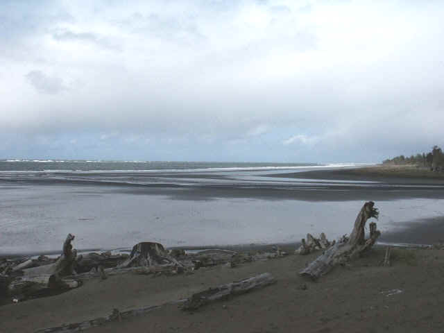
| Looking outward at the Bar, from the Washaway jetty,
with Cape Shoalwater on the right, notice breakers on the left |
 |
Crossing
the Willapa River Bar: Crossing the bar here can be dangerous for a
small boater if you are not VERY observant. As just outside the point of land, the channel angles off to
the Southwest & somewhat parallels the breakers. Recent reports are
that the bar's channel has changed to where at a low tide the depth is less than
20'.
If
the tide is a high slack & no wind, then it should be no problem, except
when you want to come back in. If you insist on using this bar, then it
may be best that on your first time out for each year, to explore it somewhat
& make GPS readings on just where the channel really is for that
year. If you have a wind & tide running, it is best that the small
boater remain inside.
"South Channel", which is a 50-60' deep large area just south of
Deadmans Island & north of Leadbetter Point. This is more protected
than the main Willapa channel which can have a severe current at the outgoing
tide. There are no buoys or markers on this "south side". This
channel shallows up considerably as it nears the ocean & breakers can be on
the outside. It is not recommended crossing here to the open ocean, unless
you do it at a high tide & then take a GPS reading from the inside so you
know where to come back across at, as the breakers all look alike from the
outside & you will not know where this channel should be. Not really
recommended however.
Heading
out from Westport / Grays Harbor:
Leaving the boat basin from the launch, head
straight out through the slot in the breakwater piling, then hang a left &
head north for the end of the short rock breakwaters at the point. DO NOT GO
EAST OF PILING MARKER #7, as it designates the edge of Whitcomb Flats.
As
you enter the main river off the point, there are a couple of rock breakwaters.
Just outside of these, there is a shallow bar of about 15-20’ depth, you may encounter a turbulence here for a couple of hundred
yards depending on the tide. Once you get beyond
this little bar, the main river deepens and the water flattens out. There is a small
red can buoy "4 T" in the middle of the exit channel. Head toward the
"4 T" buoy, then turn to the west and head out the main river.
It is suggested that after you enter the main river & can see west with the
south jetty on your left in the distance, head straight out the southern middle
of the river to #11, the next one will then be #9. This #9 buoy is beyond the
end of the south jetty by about half a mile. If you are going to encounter any
roughness it will be about this #9 buoy to beyond #8, which is about 500 yards.
From #9 you want to head toward #8, but depending on the currents & roughness
off the old submerged jetty, you may have to hold slightly north of it. When you
get beyond the old jetty turbulence, you then can head close to either side of
#8. At #8 you can immediately swing to the left & head southwest toward #6.
Buoy #8 & buoy #6 are fairly close together. After you head toward #6 you
will usually be beyond any bar wave conditions.
Distance from the launch to buoy #8 is about 5.5 miles. From the end of the
existing South Jetty to buoy #8 is about 1.5 miles. Buoy #8 is about equal in a
westerly direction as the end of the North Jetty.
Crossing
the Grays Harbor Bar:
As mentioned before, the actual bar will be from about
buoy #9 to just beyond buoy #8 under most conditions. Timing of the tide
can make a great difference as to whether you may encounter a flat bar or a
rough one. If there is no wind, or about a 10mph one, when you try to cross
and the tide is slack or within an hour after, you MAY be able to cross
at 25 mph. However if you try to cross in the middle of a tidal exchange,
things WILL be different.
The
tide exchange will govern how rough the bar is going to be. The low tides will
have one real low tide each day & the other low tide will be somewhat
higher. Look at the tide book &
compare the difference between two tides closest to the time you intend to
cross. From a fisherman’s
standpoint, if we look at the Pacific Beaches tides for July 13, 2002, the high
tide is 8.4’ at 3:33AM & the following low tide is –1.0’ at 10:26AM,
you therefore have a 9.4’ run off. The
next high tide is at 4:59PM at 7.7’ with a difference of 8.7. For
the inexperienced, this is not a really good week-end to try to cross on your
time-frame.
Using
the above figures,
if you
want to fish & cross at about 6:00AM, this
means you will be bucking the roughest section of the bar at that time.
You may consider waiting a couple of hours. This bar was crossable at 7:30AM
on this day with no real
problem, it was however a little snotty. You then can come back across about anytime
from up till 8PM with little
problems because you will be coming in on the incoming tide, into high slack
& beyond. If you cross during the mid tide you may encounter
incoming swells pushing you in. These swells will probably never be right on your
stern, but quartering, & usually from the NW. You will be going
slower than they are, so his means as these swells will catch up with you, &
pass under you. You will be rocked to the right as it rides up to you,
& then to the left as it passes under you. This can get dangerous if
you are going too fast.
Another
situation can be looked at for August 4, 2002.
The high tide is at 10:31 AM & is 5.6’, with the next low tide at
3:27 PM at 3.1’. This gives a
runoff of only 2.5’. With this low runoff, it means you can cross the bar
about anytime you wish during normal fishing hours.
Heading
out from LaPush:
The
Coast Guard has a yellow "Rough Bar"sign on the upper end of their boat coverage to the east of the launch, IF the wave height is over
4' the there will be 2 yellow flashing lights on the upper sides of this
sign. This indicates a rough bar & they have closed it for any crossing.
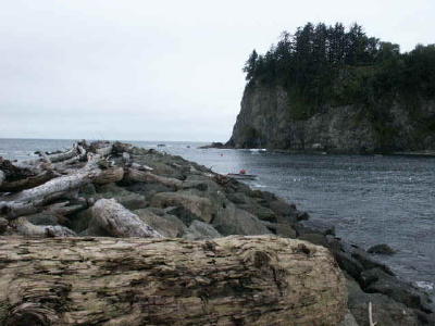
|
Indian fisherman netting in the channel |
Looking back at the channel |
 |
 |
Coming
out the Quileute River from the boat basin, you will head west. The
channel is not wide, follow the south jetty out to it's end, James Island is a
short distance to the north, (RH).
You pass between the island & the jetty. The slot is minimal (about 150') in comparison
to other river bars. Once you are past the jetty you are basically in the
ocean. You will however notice the rock on the north side of the channel
near the island. Most boaters head south out of here until they get out
beyond James Island & then make their heading change. The above pictures were taken at near a high
tide.
Conditions are
usually not severe as the island & the jetty protects most of the entrance
except possibly with a southerly wind & at low tide.
It is
suggested you take a GPS reading of this entrance for a safe return if happens to
turn foggy because there is little room for miscalculations.
Neah
Bay: Big Salmon Fishing Resort,
PO box 140, 98357 1-866-787-1900, www.bigsalmonresort.com
is run by the Makah Indian tribe, & has a installed good marina
& tackle store about the year 2000. Good ramp & moorage, with
sleeping rooms & with RV parking / cabins nearby.
One
thing to look out for here, is that if there is a East wind blowing down the
straits, don't go west out into the straits, unless you tuck in south behind
Cape Flattery out of the wind & fish near the shore. You however may be best to head east &
bottom-fish around Wadda, Sail or Seal rocks. This easterly wind can get
rough unless you are in a protected area.
There
is no real bar here as the entrance to the harbor is protected by a breakwater
& Wadda Island. But if you intend to fish the ocean, you will need to
go out past Wadda, turn around it & head west following the mainland.
You will be heading toward the south end of Tattosh Island. Here there is
a slot, (about 300 yards wide) that you will have to run thru between the
mainland & the island. There are a couple of submerged rocks in about
the middle of this slot. So it is best to hold close (48-23-32 124-44-02)
to the south side of the island as you pass it.
Once
you pass the island you are in the ocean, the conditions will usually settle down
unless there is a strong westerly wind blowing.
Coast
Guard Boarding: You can be stopped
by the US Coast Guard & boarded for about any reason. Number one is SAFETY, & are
you compliant with the required equipment aboard your boat? You have to allow them to board you, except if you feel that the location is too
rough & it will put your or your boat in jeopardy. Under these
circumstances you may request that they move the boarding location to calmer water. They will also be looking for possible drug smuggling.
If
you DO NOT have either Life Jackets, a Fire Extinguisher or
Flares, you WILL be escorted back to the launch/dock. If your
flares are expired, you just may be asked to return to shore & purchase
current ones. It is recommended that you get a USCG Auxiliary boating
safety inspection & the sticker attached to your port side
window. These volunteer inspections give you a heads up as to what
is required. To look at the requirements of this inspection, CLICK
HERE. These volunteer inspections can also be of benefit
in that if the CG were inspect boats & time may be a requirement on their
part, if there were
2 boats together, & you had the current inspection sticker & the boat
next to you did not, you could possibly get passed by.
Once
they do inspect you, you will receive a yellow copy of the boarding. If
you happen to be boarded again that season, show them your yellow copy &
they will verify that it is indeed from your recent boarding & let you go.
The
local Coast Guard does not write any tickets specifying specific fines for
violations. They forward their report to a central hearings officer that
looks over the papers & will then send you an actual citation & fine in
the mail.
Problems
on the Water & the Coast Guard is Called: If
you contact the Coast Guard for a mechanical breakdown, depending on where you
are located, they may or may not tow you in. The reason is that
legally they can not compete with commercial towing companies. So if
your breakdown was in the San Juans, Elliot Bay or out of the Columbia river, where a towing
company was close, the Coast guard would have to pass you off to a commercial
boat towing company, unless you were in an emergency situation where the boat
was sinking or there was a medical emergency involved. These towing
companies are known to charge excessive amounts of money for their
services. Probably because they have you in a situation where you have no
control, so it is advisable to purchase towing insurance.
If
you have contacted the Coast Guard & are waiting for the tow boat or if the
Coast Guard is busy with a life threatening situation, they will call you on VHF
every 1/2 hour to verify your situation. If your situation starts to
deteriorate, by either weather conditions, or your boat is taking on water etc.,
they will then contact you every 10 minutes, which could speed up their response
from stand by to go get you.
Once
they have a line on you & render assistance, be prepared for a formal
boarding where your flares, fire extinguisher, bilge pump, etc. will be looked
at when they get you to a dock.
US
Coast Guard phone numbers for the NW
Weather Phone
- Business Phone
Quillayute River 360-374-6993 360-374-6469
Grays Harbor
360-268-0622
360-268-0121
Columbia River
360-642-3565
360-642-2382
Nehalem River
503-322-3234
503-322-3531
Tillamook Bay
503-322-3234
503-322-3531
Depoe Bay
541-765-2122
541-765-2122
Yaquina Bay
541-265-5511
541-265-5381
Siuslaw River 541-902-7792
541-997-2486
Umpqua River 541-271-4244
541-271-2183
Coos Bay
541-888-3102
541-888-3267
Coquille River (Memorial Day to Labor day, WX and Business) 541-347-2038
Rogue River (Memorial Day to Labor day, WX and Business) 541-247-7219
Chetco River 541-469-4571
541-469-2242
Copyright © 2004-2006 LeeRoy Wisner All Rights Reserved
Last updated 04-09-2006
to
contact the author click here
|